Subscribe to our daily newsletter
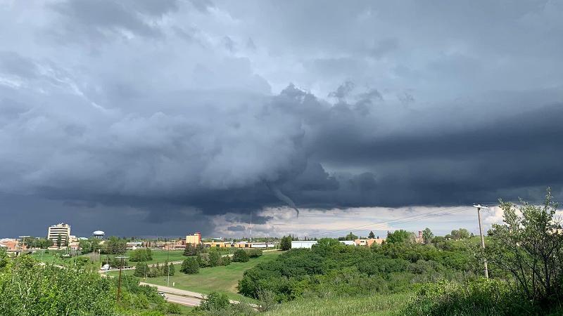
Wednesday's funnel cloud near North Battleford. (@IWeatherSK/X)
Tornado season?

Battlefords funnel cloud prompts tornado discussion from Environment Canada

May 30, 2024 | 2:01 PM

After at least one confirmed funnel cloud was spotted in the North Battleford area on Wednesday, Environment and Climate Change Canada is providing some insight into tornadoes as the province heads into another summer season.

An alert was issued for Wednesday’s funnel cloud, which Meteorologist Terri Lang confirmed never actually touched the ground.

“We know for sure that there was one really big funnel cloud that was reported and lots of pictures taken of it,” said Lang. “We don’t have any reports of it touching the ground, so no damage reported with it.”

Lang explained funnel clouds aren’t overly unusual in Saskatchewan at this time of year.

“It’s actually quite common, especially with the weather pattern that we’re having,” said Lang. “It’s a little on the cool side, it’s a little on the unsettled side, and that’s when we tend to get more funnel clouds…the vast majority of which never touch the ground.”

“They’re formed in a different process than the one type of funnels that can form into long lasting tornadoes…that comes from a different type of thunderstorm,” she continued. “So it’s just that people need to see the funnels and they need to be reported to us so that we know that they’re there because we don’t have eyes everywhere for us to see those funnels.”

Lang said funnel clouds aren’t dangerous unless they touch the ground.

“In some cases they can (touch the ground), and in that case they become what we call a landspout, which is different from a tornado that would come out of a really organized super cell type of thunderstorm,” Lang said. “So when they touch down they can cause damage…and they can be dangerous.”

Lang said Wednesday’s event was likely a cold air funnel, which can be tricky to track for meteorologists.

“They form up out of thunderstorms that spin up really really quickly, and some of these thunderstorms spin up within 15 minutes and then they’re gone 15 minutes later,” she said. “If nobody saw it we didn’t even know it was there…so really really hard to forecast.”

“We know the environment by which they can form, but super super hard to track just because when they appear on radar they don’t look like anything threatening and often we don’t see that signature spinning on the radar that we see with the well formed ones with a super cell thunderstorm.”

Lang added that people tend to get worked up over tornadoes and funnel clouds despite the fact that they don’t occur very often.

“There tends to be this fascination with tornadoes and funnel clouds and all that kind of stuff, and I’m not quite sure where it comes from,” she said. “Last year we had one tornado in Saskatchewan, so it’s not like it’s something that people should be really concentrating on or be scared of or that type of thing.”

“I think people need to be paying attention more to when we issue a severe thunderstorm warning, that when we’re forecasting very strong winds, large hail, that type of thing, that’s what people should be more concerned with I think. Lightning as well is a huge danger more so than tornadoes can be. Even though we are sort of the tornado capital of Canada…on average we get 13 or 14 tornadoes a year, and like I said last year we had one.”

More thunderstorm activity is expected in the north-central Saskatchewan region on Thursday. Lang said there could be other funnel clouds, but nothing overly severe.

“I wouldn’t be surprised if some of these cold air funnels happen again,” she said. “When it’s cooler like this we tend to get more reports.”

nolan.kowal@pattisonmedia.com

View Comments