Click here for 2024 SK Provincial Election news and info

Francine strengthens into a hurricane as Louisiana residents prepare for landfall

Sep 10, 2024 | 5:46 PM

BATON ROUGE, La. (AP) —

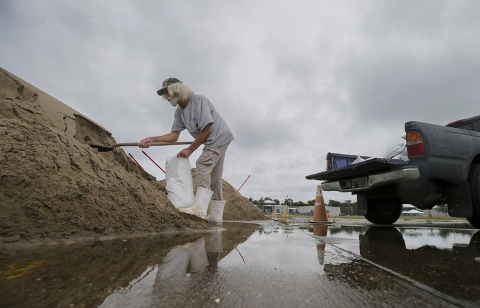
Francine has strengthened into a hurricane in the Gulf of Mexico and is advancing toward Louisiana. The National Hurricane Center said Tuesday night that Francine powered up its maximum sustained winds to 75 mph and gained hurricane status about 350 miles southwest of Morgan City, Louisiana. A hurricane warning is in effect along the Louisiana coast from the border with Texas eastward to Grand Isle, about 50 miles south of New Orleans. Storm surge warnings also are in effect in Texas and Louisiana. Francine is the sixth named storm of the Atlantic hurricane season. Evacuation orders have been issued in some coastal Louisiana communities and residents have begun filling sandbags in preparation for heavy rains and widespread flooding.

THIS IS A BREAKING NEWS UPDATE. AP’s earlier story follows below.

BATON ROUGE, La. (AP) — As Tropical Storm Francine barreled toward the Louisiana coast Tuesday, residents made last-minute preparations, including filling sandbags, buying gasoline and stocking up on necessities to face a storm that’s expected to strengthen into a hurricane before reaching land.

Residents, especially in south Louisiana, have a 24-hour window to “batten down all the hatches,” Louisiana Gov. Jeff Landry said midday Tuesday. Forecasters said Francine’s landfall was expected Wednesday afternoon or evening as a Category 2 hurricane with winds of 96 to 110 mph (155 to 175 kph) and strong storm surge.

Lifelong New Orleans resident Roxanne Riley, 42, gathered water, snacks and other food from a Walmart and said she planned to stay at a family member’s house on high ground to avoid flooding. But she was ready to evacuate if things got worse.

“It’s very frustrating every time a storm comes in,” Riley said. “I’ll just make sure my car is ready to roll in case I need to go by tomorrow. I’m going to keep on checking to see what it’s looking like.”

A hurricane warning was in effect along the Louisiana coast from Cameron eastward to Grand Isle, about 50 miles (80 kilometers) south of New Orleans, according to the National Hurricane Center. A storm surge warning stretched from the Mississippi-Alabama border to the Alabama-Florida border Such a warning means there’s a chance of life-threatening flooding.

When the storm does make landfall, Landry urged residents to stay in place rather than venturing out onto the roads and risk blocking first responders or utility crews working to repair power lines.

By late Tuesday afternoon, Francine was still a tropical storm with maximum sustained winds of 65 mph (100 kph), according to the hurricane center. The system was located about 360 miles (580 kilometers) southwest of Morgan City, Louisiana, and was moving northeast at 10 mph (17 kph).

The storm is moving over extremely warm Gulf waters that serve as fuel to strengthen it. Water temperatures are about 87 degrees (31 degrees Celsius) where Francine is located, said Brian McNoldy, senior research associate at the University of Miami’s Rosenstiel School of Marine, Atmospheric, and Earth Science.

“The ocean heat content averaged over the entire Gulf is the highest it’s been on record for the date,” McNoldy wrote on his blog.

Still, the system encountered some drier air as it moved to the north, possibly reducing the rate at which the storm intensified, forecasters said. But it is expected to reach hurricane strength anyway.

In downtown New Orleans, cars and trucks were lined up for blocks to collect sandbags from the parking lot of a local YMCA, whose CEO Erika Mann said Tuesday that 1,000 bags of sand had already been distributed by volunteers.

“I love that these are community people that came out,” Mann said. “It’s a beautiful effort to do what we do in New Orleans, we’re resilient and we come together to help in the times we need each other.”

One resident picking up sandbags was Wayne Grant, 33, who moved to New Orleans last year and was nervous for his first potential hurricane in the city. The low-lying rental apartment he shares with his partner had already flooded out in a storm the year before and he was not taking any chances this time around.

“It was like a kick in the face, we’ve been trying to stay up on the weather ever since,” Grant said. “We’re super invested in the place, even though it’s not ours.”

A little over three years after Hurricane Ida trashed his home in the Dulac community of coastal Louisiana’s Terrebonne Parish – and about a month after he finished rebuilding – Coy Verdin was preparing for another hurricane.

“We had to gut the whole house,” he recalled in a telephone interview, rattling off a memorized inventory of the work, including a new roof and new windows.

Verdin, 55, strongly considered moving farther inland, away from the home where he makes his living on nearby Bayou Grand Caillou. After rebuilding, he said he’s there to stay.

“As long as I can. It’s getting rough, though,” he said. He was preparing to head north to ride out Francine with his daughter in Thibodaux, about a 50-minute drive away. “I don’t want to go too far so I can come back to check on my house.”

Landry said the Louisiana National Guard is being deployed to parishes that could be impacted by Francine. They are equipped with food, water, nearly 400 high-water vehicles, about 100 boats and 50 helicopters to respond to the storm, including possible search-and-rescue operations.

Francine is the sixth named storm of the Atlantic hurricane season. There’s a danger of life-threatening storm surge as well as damaging, life-threatening hurricane-force winds, said Brad Reinhart, a senior hurricane specialist at the hurricane center.

There’s also the potential for 4 to 8 inches (10 to 20 centimeters) of rain with the possibility of 12 inches (30 centimeters) locally across much of Louisiana and Mississippi through Friday morning, Reinhart said. That heavy rainfall could also cause considerable flash and urban flooding.

Francine is taking aim at a Louisiana coastline that has yet to fully recover since hurricanes Laura and Delta decimated Lake Charles in 2020, followed a year later by Hurricane Ida. Over the weekend, a 22-story building in Lake Charles that had become a symbol of storm destruction was imploded after sitting vacant for nearly four years, its windows shattered and covered in shredded tarps.

Francine’s storm surge on the Louisiana coast could reach as much as 10 feet (3 meters) from Cameron to Port Fourchon and into Vermilion Bay, forecasters said.

“It’s a potential for significantly dangerous, life-threatening inundation,” said Michael Brennan, director of the hurricane center, adding it could also send “dangerous, damaging winds quite far inland.”

He said landfall was likely somewhere between Sabine Pass — on the Texas-Louisiana line — and Morgan City, Louisiana, about 220 miles (350 kilometers) to the east.

___

Associated Press writers Curt Anderson in St. Petersburg, Florida, Kevin McGill and Jack Brook in New Orleans contributed to this story.

Sara Cline, The Associated Press


View Comments