Click here to sign up for our daily newsletter.
(Highway Hotline/Twitter)
Spreading Precipitation

Winter weather to blanket Saskatchewan on Thursday

Mar 27, 2025 | 11:03 AM

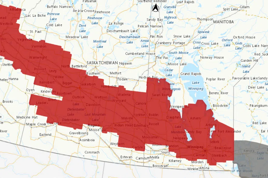
A blast of winter weather is coming to Saskatchewan on Thursday.

Environment Canada lead forecaster Brad Vrolijk said a weather disturbance is developing in Alberta, spreading precipitation across Saskatchewan on Thursday.

“This system is bringing a band of quite heavy snow to the region,” Vrolijk explained.

“We’re going to see the axis of heaviest snow stretch pretty much along the Yellowhead Highway corridor from North Battleford through Saskatoon, and then down towards Yorkton.”

Vrolijk said that area can expect 10 to 20 centimetres of snow over a 12-hour period.

“It’s going to be a bit of a mess up there today, with that snow falling a significant amount in a short period,” said Vrolijk.

In addition to snowfall, strong easterly winds will also develop.

“In that band of heavy snow, those winds are also going to be whipping it up, and we expect to see very poor visibilities at times and pretty bad travel conditions along the Yellowhead Highway corridor,” Vrolijk added.

Meadow Lake has 5 to 10 cms in the forecast for Thursday with winds gusting to 50 km/h. That is also what Environment Canada is predicting for Prince Albert and Melfort. La Ronge will see periods of lights snow. A band of freezing rain has also developed along the southern edge of the heavy snow from the Kindersley area and will migrate eastward throughout the day.

Areas around Regina and Saskatoon are dealing with two different forecasts.

“It’s kind of going to be in two main events; the first is a band of heavy snow that will develop through the morning hours and push southeast across the province. Then the second is this band of freezing rain that we’ve seen develop over Southwestern Saskatchewan this morning,” Vrolijk said.

Snowfall warnings stretched across central Saskatchewan on Thursday morning. (Environment Canada)

Regina to see freezing rain and snow

In Regina, Vrolijk said the freezing rain will be the biggest weather issue on Thursday morning.

A freezing rain warning has been issued to the north, east, and west of Regina, but not in the city itself. It comes as freezing rain mixed with snow is expected to continue through Thursday morning, making highways, roads, walkways, and parking lots slippery.

“It’s kind of on a knife’s edge as to whether it’s going to be freezing rain or snow, but just be prepared for the morning rush hour that you could end up with some ice sticking to your windshield, and the roads might get a little slippery with freezing rain,” Vrolijk explained.

He said the freezing rain is expected to last until noon, before tapering off and switching to snow.

“Along and east of Highway 11 will be the heaviest snow in the Regina area.”

By the end of the day on Thursday, Vrolijk said there could be up to 10 centimetres of snow north of Regina, but in the Queen City itself, he said there will be significantly less than that.

“If anyone’s traveling north on Highway 11 today, definitely be prepared for poor travel conditions,” Vrolijk noted.

Vrolijk said the heaviest snow is expected to move out of the province by the evening, with a prolonged period of light snow lingering throughout Friday, before tapering off Friday night.

The latest updates on the snowfall warnings can be found on Environment Canada’s website, and current road conditions can be found on the Saskatchewan Highway Hotline.