Click here to sign up for our free daily newsletter
A car was washed off the road on Highway 355, approaching the Armley Corner at Highway 35. Multiple roads have been washed out across central Saskatchewan. (Image Credit: Facebook/Ivan Beuker)
Record floods in some areas

Rural areas deal with extreme flooding as snow melts  

May 4, 2026 | 11:05 AM

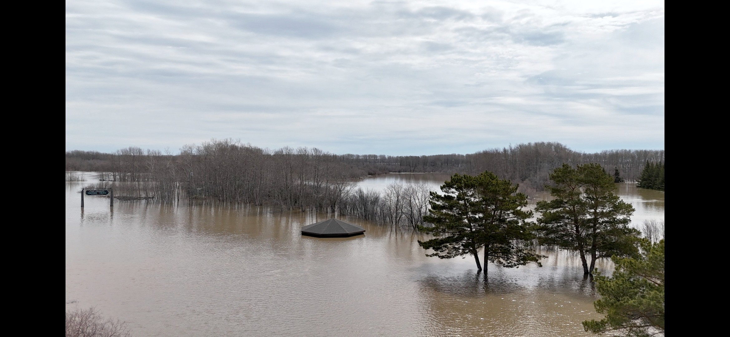
Many residents and municipalities across central Saskatchewan are reporting washed out roads and heavy localized flooding, approaching records in some areas.  

A large amount of snow, measured at about eight feet in places like Lake Country north of Prince Albert has melted quickly, causing issues with road washouts and flooded fields and golf courses.  


Facebook/Everett Murray

Northeast of Prince Albert, all the roads and area in the RM of Garden River have some level of flooding. Reeve Ryan Scragg told paNOW crews are out flagging. 

“We are just completely inundated. The flooding is unprecedented for my lifetime,” he said. 

Scragg said there is not much they can do at this point, just let the flooding take its course. To protect infrastructure, the RM is pumping around some targeted areas. 

“It’s a massive amount of water that has to move and there’s just no way to stop it.” 

Provincial highways are closed in multiple locations north, south and east of the city, continuing towards Wadena, where about 100 kilometers of Highway 5 is closed until it reaches Canora.  

The Saskatchewan Public Safety Agency has 18 active floods on its website. Last year at the same time, the number was 50 per cent of that. An update is expected from the SPSA early this afternoon.  

Just before noon on Monday, the RM of Buckland issued a warning to residents in the Shell River/Sturgeon River area near the Whitestar Road that they should be prepared for the high risk of flooding.

“All residents in the surrounding areas are urged to remain alert and take appropriate precautions. Monitor water levels closely, be prepared for rapidly changing conditions, and ensure that emergency plans and supplies are in place. Avoid low-lying areas and do not attempt to cross flooded roadways,” said the RM.

Meanwhile, the Water Security Agency said on Sunday that people can expect the conditions to last for a few days.  

Sustained warm temperatures throughout the weekend have resulted in increased streamflows throughout the areas of East Central Saskatchewan where the snowpack was not yet depleted, and in some cases the peak flow has not yet been seen.   

“Recent flow measurements and preliminary analysis suggest that in several streams the flows occurring now are or approaching the highest on record,” the SPSA wrote.  

Hardest hit at the moment are the headwaters of the Carrot River and the northern regions of the Quill Lake and Assiniboine river basins.  

The Pasquia Regional Park and golf course, near Carrot River.
The Pasquia Regional Park and golf course, near Carrot River. (Image Credit: Facebook/Hans Meyer)

Peak water levels are quickly approaching for tributaries but main bodies of water are still rising, the WSA said.   

Other areas, including the Red Deer basin, Nipawin, Prince Albert, and the Beaver River, are also responding to the warm temperatures, though with increases of a lesser magnitude. Above normal flows are expected to continue over the next few days. 

The RM of Connaught that surrounds Tisdale has declared a state of emergency and the RM of Paddockwood northeast of Prince Albert will hold a special meeting this afternoon to do the same.  

Residents of Paddockwood are advised to keep receipts for flood related expenses as the RM will be applying for disaster relief from the province.  

Near Smeaton, Ron Knutson took some video of the water flowing over Highway 55 between Choiceland and Snowden.

Knutson lives near the hamlet of Garrick in the municipality of Torch River.  He’s been driving that stretch of Highway 55 daily for the better part of 20 years.

“I’ve seen water cross in a few places usually near creeks and smaller rivers, but I have never seen that much water come, especially for the distance,” he said. The stretch of road remains open, but Knutson said it wouldn’t take much to get worse.  


Facebook/Ron Knutson

The Pasquia Regional Park and golf course north of Carrot River has flooded as has the Tisdale golf course. In Tisdale, the water is deep enough that people are wakeboarding down roads, pulled behind a vehicle and passing a Sea-Doo at the same time.  

Further north, residents of English River First Nation spent the weekend watching for floods and preparing for possible evacuation as well. Residents were not able to drive in or out of the community, including in Patuanak.

Highway closures 

Highway 3 Brancepeth – Both directions of travel are closed, water is over the road and washouts have happened. Use an alternate route. 

Highway 5 Watson – both directions of the highway half a kilometre west of Watson are closed. A detour is in place along range roads; water is over the road.  

Highway 5 Quill Lake – Both directions of highway five kilometres east of Quill Lake are closed, deep flooding is on or over the road, use an alternate route.  

Highway 5 Wadena  to Canora – 100 km of highway is closed with flooding in multiple locations along the stretch. Water is over the highway, use an alternate route.  

Highway 23 – flooding on Birth Road 13 km east of Highway 23, all lanes are closed. A local detour is in place, use an alternate route.  

Highway 25 near St. Louis – Flooding has closed Highway 25 4 km east of St. Louis. All lanes are closed and washouts have happened. Detour is in place for light traffic.  

Highway 55 – Flooding on the Meath Park grid road, all lanes are closed, water is over the road. Use an alternate route.  

Highway 320 Domremy – Both directions east of Domremy are closed, water is over the road and has caused washouts.  

Highway 355 – both directions at Highway 2 are closed, there is a local detour. Water is over the road.  

Highway 355 Pontrilas – Both directions of travel pm at Highway 35 in the Pontrilas, Armley area are closed. Use an alternate route.  

Highway 355 – east of intersection with Highway 35, all lanes are closed. Water has washed out part of the road, water is over the road.  

Highway 916 – Flooding in both directions 28 kms west of Highway 2. All lanes are closed, use an alternate route.

Highway 918 – both directions 20 kms of north of Highway 165. A washout exists and water is over the road.

Highway 936/Highway 2 – both directions closed due to culvert washout. No detour is available, use an alternate route.

Highway 2/Regional Park Road one kilometre east. All lanes are closed, water is on the road and has washed out parts.  

-local roads are washed out in many locations and may not be listed on the Highway Hotline.  

 —

susan.mcneil@pattisonmedia.com